If you are preparing for a construction project, property improvement, or permit application, you may come across terms such as site plan, plot plan, and site survey. At first, these terms can sound interchangeable. They are not always the same thing.
A homeowner may hear a city request a plot plan, see a designer refer to a site plan, and then be told that a survey is needed before the drawings can be completed. That can make the permitting process more confusing than it needs to be. The important thing to understand is that these documents serve different purposes.
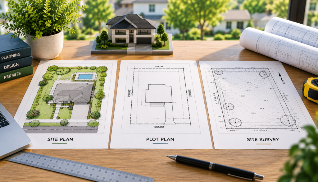
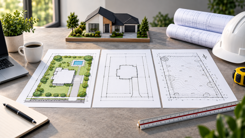
A site plan generally communicates how a property is arranged and how existing or proposed improvements relate to the site. A plot plan is often used for a similar type of property layout drawing, although the terminology can vary between jurisdictions and professionals. A site survey is a professional measurement and documentation of existing property conditions.
The names are sometimes used differently from one city or project to another, so the safest approach is to look at what the permitting agency is actually asking for rather than relying only on the title of the document.
Site Plan vs Plot Plan vs Site Survey at a Glance
Here is the simplest way to understand the difference:
| Document | Main Purpose | Typically Shows |
| Site Plan | Shows existing and/or proposed site development | Structures, property lines, setbacks, access, parking, proposed improvements |
| Plot Plan | Shows the layout of a building or improvement on a specific lot | Property boundaries, building location, dimensions, setbacks, site features |
| Site Survey | Measures and documents existing property conditions | Boundary information, structures, elevations, features, and other surveyed conditions |
There can be overlap between these documents.
For example, a site plan and plot plan may look very similar. A survey may provide the measurements and existing-condition information used to prepare either one. That is why understanding the purpose of each document is more useful than focusing only on terminology.
What Is a Site Plan?
A site plan is a drawing that shows a property from above and communicates how buildings and other site features relate to one another. It can show existing conditions, proposed improvements, or both. Depending on the project, a site plan may include:
- Property lines
- Existing buildings
- Proposed buildings
- Building dimensions
- Setbacks
- Driveways
- Parking
- Easements
- Walkways
- Fences
- Pools
- Utilities
- Landscaping
- Grading or drainage information
- North arrow
- Drawing scale
The exact information depends on the project and the local jurisdiction.
For example, a homeowner planning a new addition may use a site plan to show the existing house and proposed addition in relation to the property boundaries. Someone planning a detached ADU may need a site plan showing the main residence, proposed ADU, garage, setbacks, access, parking, and other relevant site conditions.
What Is a Plot Plan?
A plot plan is generally a drawing showing how a building or proposed improvement is positioned on a particular parcel of land. In many situations, the terms plot plan and site plan overlap considerably. A plot plan may show:
- Property boundaries
- Lot dimensions
- Building footprint
- Building-to-property-line distances
- Setbacks
- Driveway
- Access
- Other relevant site features
The terminology is not completely standardized. One jurisdiction may call the document a plot plan while another uses the term site plan for a similar drawing. Some agencies may use both terms but apply them to different project types. This is why homeowners should not assume that a document called a “site plan” will automatically satisfy a request for a “plot plan.” The actual submittal requirements matter more than the label.
What Is a Site Survey?
A site survey is different from a typical permit drawing because its primary purpose is to document measured conditions on the property. A survey may establish or document information such as:
- Property boundaries
- Building locations
- Site improvements
- Elevations
- Topographic features
- Easements or rights-of-way, depending on the survey type
- Other physical conditions
The type of survey required depends on the project. A boundary survey focuses on property boundaries. A topographic survey provides information about elevations and terrain. Other survey types may address additional property or development conditions. A survey is generally prepared by an appropriately licensed surveying professional when a project requires professional surveying services.
The survey is therefore not simply another version of a site plan. It can provide the reliable existing-condition information that a designer, architect, engineer, or drafter uses when preparing the project drawings.
The Biggest Difference: Measured Conditions vs Permit Presentation
One useful way to understand the difference is to consider what each document is trying to accomplish.
A survey answers:
“What is actually there, and where is it located?”
A site plan answers:
“How is the property arranged, and what is being proposed?”
A plot plan often answers:
“Where is the building or improvement located on this particular lot?”
There is overlap, but the purpose is different.
A survey can provide the underlying site information. The site or plot plan can then organize that information into a drawing that communicates the proposed project for review.
Site Plan vs Plot Plan
The difference between a site plan and plot plan can be difficult because many jurisdictions use the terms differently. In practical terms, both can involve a top-down drawing of a property showing buildings, property lines, dimensions, and setbacks. However, there are situations where the terminology may suggest a different level or purpose.
Site Plan
A site plan often provides a broader view of site development.
It may include:
- Existing conditions
- Proposed construction
- Access
- Parking
- Landscaping
- Utilities
- Drainage
- Other site improvements
It is commonly used when the reviewer needs to understand how a project affects the overall property.
Plot Plan
A plot plan often focuses more directly on the location of a building or proposed improvement within the lot.
It may emphasize:
- Property boundaries
- Building footprint
- Setbacks
- Lot dimensions
- Building dimensions
- Access
For a simple residential permit, a plot plan may be relatively straightforward. But again, these descriptions are not universal definitions. Local agencies can use the terms differently.
Site Plan vs Site Survey
The distinction between these two is generally clearer. A site survey documents existing physical or property conditions based on professional measurement. A site plan uses site information to communicate the existing and proposed arrangement of the property. For example, imagine a homeowner wants to build a detached garage.
A survey might establish the property’s boundaries, existing structures, elevations, and other relevant conditions. A site plan can then show the proposed garage in relation to those conditions, including its dimensions and setbacks. The survey and site plan therefore work together rather than replacing one another.
Plot Plan vs Site Survey
A plot plan is also not automatically a substitute for a survey. A plot plan may show where a structure is proposed, but that does not necessarily mean the property boundaries or existing conditions have been professionally surveyed. For a simple project, the local jurisdiction may accept existing property information or another source of measurements.
For a more complicated project, a survey may be necessary to establish accurate conditions before the plot plan is prepared. The requirement depends on the project and agency.
When Might a Homeowner Need a Site Plan?
A site plan may be required for projects that add new structures or make significant changes to the property. Common examples include home additions, ADUs, new construction, detached garages, pools, and commercial improvements.
For a home addition or ADU, the plan can show the existing residence, proposed work, property boundaries, setbacks, access, parking, and other relevant features. New construction and detached garages also need to be positioned accurately in relation to property lines and existing structures.
Pool projects may require the proposed pool, fences, property lines, and nearby structures to be shown. Commercial improvements can require more detailed information about parking, access, circulation, landscaping, utilities, and other site conditions. The exact requirements depend on the project and the local jurisdiction reviewing the application.
When Might a Homeowner Need a Plot Plan?
A plot plan may be requested for a building permit or another application where the agency needs to understand the placement of a structure on a particular lot. For example, a jurisdiction might ask for a plot plan showing:
- Property lines
- Proposed structure
- Building dimensions
- Setbacks
- Driveway
- Existing structures
- Other relevant information
If the agency specifically asks for a plot plan, use its checklist rather than assuming a generic site plan will meet the requirement.
When Might a Homeowner Need a Site Survey?
A survey may become important when accurate property or site measurements are necessary.
Situations can include:
- Unclear property boundaries
- New construction
- Complex site conditions
- Significant grading
- Topographic changes
- Boundary concerns
- Projects close to property lines
- Development involving multiple structures
Not every permit project requires a new survey. However, homeowners should not assume that a rough measurement or online map is sufficient when the project requires professionally established site information.
Do You Always Need All Three?
A homeowner does not automatically need a site plan, plot plan, and survey for every project.
The documents required depend on:
- Project type
- Property conditions
- Local jurisdiction
- Scope of construction
- Required permit documents
- Whether accurate survey information is already available
A simple project may require only a basic plot or site plan. A more complicated project may require a survey first and then detailed site, architectural, grading, or engineering drawings. The best approach is to determine the required documents before investing in the final drawings.
How the Documents Can Work Together
Consider a homeowner planning a detached ADU. The process could look like this:
Step 1: Understand the existing property
Existing property information, measurements, or a survey may establish the site’s current conditions.
Step 2: Determine the proposed ADU location
The designer considers property boundaries, existing structures, setbacks, access, parking, and other constraints.
Step 3: Prepare the site or plot plan
The proposed ADU is shown on the property with the relevant dimensions and site information.
Step 4: Coordinate with other drawings
The site plan is checked against the architectural and other permit documents.
Step 5: Submit the required package
The documents are submitted according to the local agency’s requirements. The important point is that each document has a role.
Can a Site Plan Be Prepared From a Survey?
A survey can provide valuable existing-condition information for preparing a site plan. For example, if a survey establishes the property boundaries and locations of existing structures, those measurements can be used as the basis for showing a proposed addition or ADU.
However, the survey itself does not necessarily become the final permit site plan. The project drawings still need to communicate the proposed work and meet the applicable submittal requirements.
Can a Plot Plan Be Prepared Without a Survey?
Sometimes. Whether a survey is required depends on the jurisdiction and project. For certain straightforward residential projects, the agency may accept a plot plan based on existing property information and measurements.
For projects where property boundaries, elevations, or other conditions need to be professionally established, a survey may be required. Do not assume that a survey is unnecessary simply because a plot plan can be drawn without one. The two documents serve different purposes.
Why the Terminology Causes Confusion
The main reason these terms are confusing is that site plan, plot plan, and site survey are not used the same way everywhere. One city may use “plot plan” for a residential permit drawing, while another may call a similar drawing a “site plan.” A designer may also use “site plan” as a broader term covering both existing and proposed conditions.
A site survey is generally based on professionally measured site information, but its scope can vary depending on the project and what needs to be established.
Instead of asking, “Do I need a site plan or plot plan?”, ask:
“What drawing does my permitting agency require, and what information must it contain?”
That question usually provides a much clearer answer.
Common Mistakes Homeowners Make
Several common misunderstandings can make the site planning and permitting process more difficult.
Assuming the Terms Mean Exactly the Same Thing: Site plans and plot plans can overlap, but local agencies may use these terms differently. Always check the terminology and requirements used by your city or county.
Treating a Survey as a Permit Drawing: A survey documents existing property and site conditions, but it does not automatically include every detail required for a permit site plan.
Using Online Maps as Exact Property Information: Satellite imagery and online maps can provide general reference information, but they should not replace professionally established property boundaries or accurate measurements.
Preparing the Drawing Before Checking Requirements: Starting the drawing before reviewing the local permit checklist can lead to missing information, revisions, and unnecessary delays.
Ignoring Existing Conditions: The proposed project should be evaluated against existing buildings, driveways, fences, utilities, landscaping, and other relevant site features.
Assuming One Document Replaces Another: Surveys, site plans, and plot plans can serve different purposes. Depending on the project and jurisdiction, more than one document may be required.
Which One Do You Need for Your Project?
The answer depends on what you are doing.
| Project Situation | Possible Document Need |
| Simple residential improvement | Site or plot plan may be sufficient |
| New detached structure | Site or plot plan, with survey information if required |
| ADU | Site plan or plot plan showing existing and proposed conditions |
| Project near property lines | Survey may be useful or required |
| Complex grading project | Survey plus detailed site/grading documentation may be needed |
| Commercial development | More detailed site documentation may be required |
This table is only a general guide. The local permitting agency’s current requirements should determine what documents are actually submitted.
When Professional Help Makes Sense
The terminology may be confusing, but the bigger issue is making sure the right information is represented accurately. Professional drafting can help organize property information into a clear site or plot plan. This can be useful when:
- You are preparing an ADU
- You are adding square footage
- You are building a detached structure
- The property has multiple buildings
- Setbacks are tight
- Easements affect the property
- Access or parking is complicated
- The permit department has detailed drawing requirements
If a licensed surveyor, architect, engineer, or other professional is required, drafting services do not replace those professional responsibilities. The right team depends on the scope of the project.
Final Thoughts
When comparing site plan vs plot plan, remember that the terms can overlap. Both may describe drawings showing a property’s layout, structures, dimensions, setbacks, and proposed improvements. A site survey is different because it focuses on documenting measured existing property and site conditions.
In simple terms:
- Site plan: Shows the site and proposed development.
- Plot plan: Commonly shows the placement of a building or improvement on a specific lot.
- Site survey: Documents measured existing conditions.
Depending on the project and local requirements, you may need one, two, or all three. The best starting point is your city or county’s current permit checklist.
Need help preparing a site plan for your California project? Our team can help organize your property information and proposed improvements into a clear, professional site plan for the permit process. Contact us to discuss your project and determine the appropriate next step.
Frequently Asked Questions
Is a site plan the same as a plot plan?
Not always, but the terms can overlap. Some jurisdictions use “site plan” and “plot plan” for similar permit drawings. Always follow the terminology and requirements used by the agency reviewing your project.
Is a site survey the same as a site plan?
No. A survey documents measured property or site conditions, while a site plan communicates the existing and proposed arrangement of the property for a particular project.
Do I need a survey to prepare a site plan?
Not necessarily. Some projects can be prepared using existing reliable property information. Other projects may require a survey because of property boundaries, elevations, site complexity, or local requirements.
Can I use a plot plan instead of a site plan?
Only if the permitting agency accepts it for the specific application. Because terminology varies, compare the drawing requirements rather than relying on the title alone.
Which is more accurate, a site plan or a survey?
They are not directly competing documents. A survey is generally based on professional measurement of existing conditions, while a site plan is a project drawing that communicates site information and proposed improvements.
Do ADU projects need a site plan or plot plan?
Many ADU permit applications require site-related drawings, but the exact document name and information required depend on the jurisdiction and project. The local permit checklist should be used to determine what is needed.
Who prepares a site survey?
When professional surveying is required, it should be performed by an appropriately licensed surveying professional. The specific type of survey depends on the project’s needs.